The Yamuna River System is a crucial component of the Ganga Drainage System, originating from the Himalayas and flowing through the northern part of the Indian subcontinent. It is vital for the sustenance of millions of people, providing water for agriculture, drinking, and supporting diverse ecosystems. This article aims to study in detail the origin, course, and tributaries of the Yamuna River System.
About Yamuna River System
- The Yamuna River System is an integral part of the Ganga Drainage System, which is one of the three major river basins in the Himalayan region.
- The Yamuna River and its numerous tributaries flow through the northern part of the Indian subcontinent, significantly influencing the landscape and supporting diverse ecosystems along its course.
- With a total length of over 1,300 kilometres, the Yamuna is a crucial river in India and an essential tributary of the Ganga River.
Origin of Yamuna River System
- The Yamuna River originates from the Yamunotri Glacier near Bandarpoonch Peak in the Mussoorie range of the Lower Himalayas.
- This glacier is situated at an altitude of approximately 6,387 meters in the Uttarkashi district of Uttarakhand, India.
- The Yamuna River begins its journey from this glacier, marking the source of one of India’s most significant rivers.
Course of Yamuna River System
- The Yamuna River flows along states of Uttarakhand, Himachal Pradesh, and Haryana and, enters Delhi and merges with the Ganga near Triveni Sangam, Allahabad (Prayagraj).
- It is the largest tributary of the Ganga in the northern plains.
- Its main affluent in the upper reaches is the Tons which also rises from the Bandarpoonch glacier.
Tributaries of Yamuna River System
The tributaries of the Yamuna River System have been discussed in detail in the section that follows:
Tons River
- The Tons is the longest and biggest tributary of the Yamuna River, and it flows through Garhwal, the western part of the Himalayan state of Uttarakhand.
- The river begins at an elevation of 3,900 meters and merges with the Yamuna below Kalsi near Dehradun, Uttarakhand.
- It is one of the major perennial rivers in the Indian Himalayas.
Giri River
- The Giri River is a significant tributary of the Yamuna River and serves as the primary water source in southeastern Himachal Pradesh.
- It is well-known in the Jubbal and Rohru hills, which originate from Kupar Peak.
Hindon River
- Hindon River is an important tributary of the Yamuna River and originates from upper Shivalik (Lower Himalayas).
- In fact, this river is sandwich between two major rivers, i.e. Ganga on the left and Yamuna on the right.
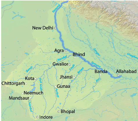
Chambal River
- The Chambal River, also referred to as Charmanwati or Charmawati originates from the Janapao Hills on the southern slopes of the Vindhya Range in Madhya Pradesh.
- Due to severe erosion from poor rainfall, the river flows significantly below its banks, creating numerous deep ravines in the Chambal Valley and giving rise to badland topography.
Dams on the Chambal River
There are four significant dams on the Chambal River located from South to North:
- Gandhi Sagar Dam
- Rana Pratap Sagar Dam
- Jawahar Sagar Dam
- The Kota Barrage
Water released after power generation at Gandhi Sagar Dam, Rana Pratap Sagar Dam, and Jawahar Sagar Dam is diverted by the Kota Barrage for irrigation in Rajasthan and Madhya Pradesh through a network of canals.
| Note: Keoladeo National Park is supplied with water from the Chambal River Irrigation Project. |
Banas River
- The Banas River is also known as ‘Van Ki Asha’(Hope of Forest).
- It originates in the Aravalli Range in Rajsamand District of Rajasthan.
Kali Sindh River
- The Kali Sindh River flows in the Malwa region of Madhya Pradesh and joins the Chambal River near Sawai Madhopur in Rajasthan.
Sindh River
- The Sindh River originates on the Malwa Plateau in Vidisha district and flows north-northeast through the districts of Guna, Ashoknagar, Shivpuri, Datia, Gwalior, and Bhind in Madhya Pradesh.
- It joins the Yamuna River in Etawah District (UP) and flows through Madhya Pradesh and Uttar Pradesh.
Betwa River
- The Betwa River, also known as Vetravati, rises in the Vindhya Range north of Hoshangabad in Madhya Pradesh.
- The confluence of the Betwa and Yamuna Rivers occurs in Hamirpur, a town in Uttar Pradesh.
Ken River
- The Ken River originates from the slopes of the Kaimur Range in the Jabalpur district of Madhya Pradesh.
- It merges with the Yamuna near Fatehpur in Uttar Pradesh.
- The Ken Valley separates the Rewa Plateau from the Satna Plateau and passes through Panna National Park.
States through which Yamuna River Flows
| States | Uttarakhand, Himachal Pradesh, Uttar Pradesh, Haryana, and Delhi. |
Cities located on the banks of Yamuna
| Cities | Noida, Mathura, Agra, Firozabad, Etawah, Kalpi, Hamirpur and Prayagraj (Allahabad). |
Challenges faced by Yamuna River System
The Yamuna River System has faced severe environmental degradation, posing a grave threat to the communities and ecosystems that depend on it. The primary challenges facing the Yamuna include:
- Pollution and Waste Dumping – The Yamuna has become one of the most polluted rivers in the country, with high levels of industrial effluents, sewage, and solid waste being dumped into its waters.
- This has led to a significant decline in water quality, making it unsuitable for drinking, bathing, or even agricultural use.
- Declining Groundwater Levels – Excessive groundwater extraction, particularly for agricultural and industrial purposes, has led to a significant decline in groundwater levels in the Yamuna basin.
- This has further exacerbated the water scarcity issues in the region.
- Encroachment and Habitat Destruction – The rapid urbanisation and industrialisation along the Yamuna’s banks have led to the encroachment of wetlands, floodplains, and other ecologically sensitive areas.
- This has not only disrupted the river’s natural flow but also destroyed the habitats of numerous aquatic and terrestrial species.
- Climate Change Impacts – The Yamuna River system is also facing the adverse effects of climate change, including erratic rainfall patterns, glacial retreat, and an increase in the frequency and intensity of extreme weather events.
- These changes have further exacerbated the water-related challenges in the region.
To address these pressing issues, various government and non-governmental initiatives have been launched, such as the Yamuna Action Plan and the National Mission for Clean Ganga. These efforts have focused on improving sewage treatment, controlling industrial pollution, and promoting community-based conservation efforts.
Conclusion
By prioritising the restoration and conservation of the Yamuna River system, we can safeguard the livelihoods and well-being of millions of people and preserve the rich biodiversity and ecological balance of this vital natural resource. The future of the Yamuna and the communities it sustains depends on our collective efforts to protect and revive this lifeline of the Indian subcontinent.
Frequently Asked Questions (FAQs)
What is Yamuna River system?
The Yamuna River System is a major river system in northern India, forming a crucial part of the Ganga Drainage System. It includes the Yamuna River and its various tributaries, flowing through the states of Uttarakhand, Himachal Pradesh, Haryana, and Uttar Pradesh, before joining the Ganga River at Prayagraj (Allahabad).
What is the Yamuna Action Plan?
The Yamuna Action Plan (YAP) is a comprehensive initiative launched by the Indian government to address the severe pollution and environmental degradation of the Yamuna River.
Yamuna river flows through which states?
The Yamuna River flows through the states of Uttarakhand, Himachal Pradesh, Haryana, Delhi, and Uttar Pradesh. It originates in Uttarakhand and eventually merges with the Ganga in Uttar Pradesh.


