
The Ganga River System is one of the major river systems in India, originating from the Himalayas and flowing across the northern and eastern parts of the subcontinent. It is vital for the sustenance of millions of people, providing water for agriculture, drinking, and supporting diverse ecosystems. This article aims to study in detail the origin, course, and tributaries of the Ganga River System.
About Ganga River
- The Ganga River System is one of the three major river basins that comprise the Himalayan Drainage System.
- The Ganga River and its numerous tributaries flow through the northern and eastern parts of the Indian subcontinent, shaping the landscape and sustaining diverse ecosystems along its course.
- With a total length of over 2,500 kilometres, the Ganga is the most important river in India and one of the longest in Asia.
Origin of Ganga River
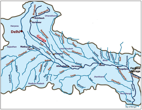
- The Ganga River is a major river of the Indian subcontinent rising in the Himalayan mountains and flowing about 2,525 km generally eastward through a vast plain to the Bay of Bengal.
- Flowing through a vast length, it crosses five states of India namely:
- Uttarakhand,
- Uttar Pradesh,
- Bihar,
- Jharkhand and
- West Bengal.
- It has a catchment area of 8,61,404 sq. km (26.4%) of India.
- Finally, it drains into the Bay of Bengal. The Ganga River basin is among the most densely populated in the world, housing about half of India’s population.
- It supplies over one-third of India’s surface water and accounts for more than half of the country’s water use.
- Beyond its vital role in daily life, the Ganga is also revered as one of India’s holiest rivers, with cultural and spiritual significance extending far beyond the basin.
Course of Ganga River
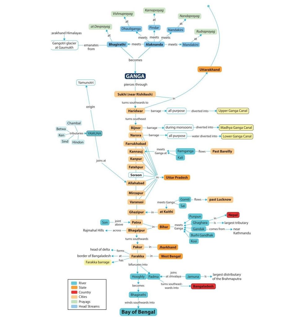
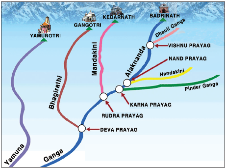
- The Bhagirathi, considered to be the source stream of the Ganga, emanates from Gangotri Glacier at Gaumukh at an elevation of 3, 892 m (12,770 feet).
- Many small streams comprise the headwaters of the Ganga. The important among these are:
- Alaknanda,
- Dhauliganga,
- Pindar,
- Mandakini and
- Bhilangana.
- At Devprayag, where the Alaknanda meets the Bhagirathi, the river is named Ganga.
- As it flows into the Gangetic Plains at Haridwar, a barrage channels a substantial portion of its water into the Upper Ganga Canal for irrigation purposes.
- Another barrage at Bijnore directs water into the Madhya Ganga Canal, but this occurs only during the monsoon season.
- At Narora, water is further diverted into the Lower Ganga Canal.
- Additionally, the Ramganga River joins the Ganga near Kannauj, contributing extra water to the river.
- Yamuna confluences Ganga at the Sangam in Prayagraj (Allahabad), making a major contribution to the river flow.
- Beyond Prayagraj, Ganga is joined by several tributaries, most of which are from the north and a few from the south.
- The Farakka barrage in West Bengal regulates the flow of the Ganga River, diverting a portion of its water into a feeder canal that connects to the Hooghly River, helping to keep it relatively free of silt.
- Below the Farakka barrage, the Ganga River divides into two branches:
- Bhagirathi (Hooghly) is on the right and
- Padma is on the left.
- The Bhagirathi (Hooghly) River meets the Bay of Bengal approximately 150 km downstream from Kolkata.
- Padma enters Bangladesh and meets rivers Brahmaputra and Meghna before finally joining the Bay of Bengal.
Tributaries of Ganga River
The major tributaries of the Ganga River are:
- Yamuna,
- Ramganga,
- Gomti,
- Ghaghara,
- Gandak,
- Damodar, and
- Kosi etc.
Some important tributaries of the Ganga River System have been discussed in detail in the section that follows.
Alaknanda River
- The Alaknanda River is one of the primary headstreams of the Ganga River.
- It originates at the confluence of the Satopanth and Bhagirath glaciers in Uttarakhand.
- It meets the Bhagirathi River at Devprayag after which it is called as the Ganga River.
- Its main tributaries are the:
- Mandakini,
- Nandakini, and
- Pindar rivers.
- The Hindu pilgrimage centre of Badrinath and the natural spring Tapt Kund lie along the banks of the Alaknanda River.
- At its origin, Lake Satopanth is a triangular lake named after the Hindu trinity Lord Brahma, Lord Vishnu, and Lord Shiva.
Bhagirathi River
- The Bhagirathi River is one of the two major headstreams of the Ganga.
- It converges with the Alaknanda at Devprayag to form the Ganga River.
- It rises at the foot of Gangotri Glacier, at Gaumukh, at the base of Chaukhamba peak in the Uttarkashi district of Uttarakhand.
- The upper catchment of the river is glaciated. It cuts spectacular gorges in its middle course where it cuts through granites and crystalline rocks of the central Himalayas.
Dhauliganga River
- The Dhauliganga River originates from Vasundhara Tal, perhaps the largest glacial lake in Uttarakhand.
- The Dhauliganga is a significant tributary of the Alaknanda, alongside the Nandakini, Pindar, Mandakini, and Bhagirathi.
- It is joined by the Rishiganga River at Raini.
- It merges with the Alaknanda at Vishnuprayag. There it loses its identity and the Alaknanda flows southwest through Nandaprayag, Karnaprayag until it meets the Mandakini River, which comes from the north at Rudraprayag.
- After subsuming the Mandakini, the Alaknanda continues past Srinagar before merging with the Ganga at Devprayag.
- The Alaknanda then fades into the Ganga, which proceeds first southward and then westward through notable pilgrimage sites like Rishikesh before entering the Indo-Gangetic plains at Haridwar.
- Additionally, the Tapovan Vishnugad Hydropower Project is under construction on the Dhauliganga.
Rishiganga River
- Rishiganga River originates from the Uttari Nanda Devi Glacier on Nanda Devi Mountain and is also nourished by the Dakshini Nanda Devi Glacier.
- It flows through the Nanda Devi National Park and merges into the Dhauliganga River near the village of Raini.
Ramganga River
- The Ramganga River originates on the southern slopes of Dudhatoli Hill in the Chamoli district of Uttarakhand.
- It is fed by springs that rise from underground water reservoirs.
- The river’s course through the lower Himalayan hills features distinct geomorphic characteristics such as incised meanders, paired and unpaired terraces, interlocking spurs, waterfalls, rock benches, cliffs, and towering ridges.
- It flows through the Dun Valley of Corbett National Park and is dammed at Kalagarh.
- The Ramganga ultimately joins the Ganga near Kannauj, with Bareilly City situated along its banks.
Gomti River
- The Gomti River originates from Gomat Taal which formally is known as Fulhaar Jheel, near Madho Tanda, Pilibhit in Uttar Pradesh.
- It meets the Ganges River in Ghazipur. At the confluence of the Gomti and Ganga rivers, the renowned Markandey Mahadeo Temple is located.
- The Sai River, a significant tributary, merges with the Gomti near Jaunpur.
- The cities of Lucknow, Lakhimpur Kheri, Sultanpur, and Jaunpur are situated along the banks of the Gomti River.
Ghaghara River
- The Ghaghara originates in the glaciers of Mapchachungo.
- It is also known as Karnali or Kaurial.
- It is a transboundary perennial river originating from the Tibetan plateau near Lake Mansarovar.
- It flows through the Himalayas in Nepal and is joined by the Sharda River at Brahmaghat in India.
- It is a major left-bank tributary of the Ganga and merges with it at Chhapra in Bihar.
- Rapti, Chhoti Gandak, Sharda, and Saryu are the major tributaries of this river.
Sharda River
- The Sharda River originates from the Milam Glacier in the Nepal Himalayas, where it is known as the Goriganga.
- In Uttarakhand’s Pithoragarh District, it is also referred to as the Kali River and rises from Kalapaani, a significant site on the route of the Kailash Manasarovar Yatra.
- The river flows in a gorge section in the upper region of Himalayas.
- The Mahakali after it descends into the plains of India is known as Sarda, which meets the Ghaghara.
Sarayu River
- The Sarayu is a river that flows through Uttar Pradesh and Uttrakhand.
- Sarayu is a river that originates from a ridge south of Nanda Kot Mountain in Bageshwar district, Uttarakhand.
- This river holds ancient significance and is mentioned in the Vedas and the Ramayana.
- It is a left-bank tributary of River Sharda.
Rapti River
- The Rapti River originates south of the western Dhaulagiri Himalayas and the Mahabharat Range in Nepal.
- Its main channel emerges from springs on the southern slopes of the lower Himalayas.
- The river is essentially fed by underground water. It has the tendency of recurrent floods that led to its nickname Gorakhpur’s Sorrow.
Gandak River
- The Gandak River is formed by the union of the Kali and Trisuli rivers, which rise in the Great Himalayan Range in Nepal.
- From this junction to the Indian border, the river is known as the Narayani.
- It enters the Ganga River opposite Patna in a place called Sonepur.
- The middle and the lower courses of the river flow through the V-shaped valleys, incised meanders, and have paired and unpaired terraces on either side.
Kosi River
- The Kosi River is also known as Saptakoshi for its 7 Himalayan tributaries.
- It is an antecedent transboundary river that flows through both Nepal and India.
- This river is one of the largest tributaries of the Ganga and joins it at Kursela in the Kathiar district.
- The Kosi River’s catchment includes the highest peak in the world, Mount Everest, and Kanchenjunga.
- Its unstable nature, attributed to the heavy silt it carries during the monsoon season, has earned it the nickname Sorrow of Bihar.
Son River
- The Son River originates near Amarkantak in Madhya Pradesh, just east of the Narmada River’s headwaters, and flows north-northwest through Madhya Pradesh.
- The Son parallels the Kaimur hills, flowing east-northeast through Uttar Pradesh, Jharkhand, and Bihar states to join the Ganga just above Patna.
| Note: The Right-bank tributaries are: – Gopat River, – Rihand River, – Kanhar River, and – North Koel River. The Left-bank tributaries are: – Ghaggar River, – Johila River, and – Chhoti Mahanadi River |
Rihand River
- The Rihand rises from Matiranga Hills in the region southwest of the Mainpat plateau, in Chhattisgarh.
- The Rihand Dam was constructed across the Rihand River, the reservoir impounded behind the dam is called Govind Ballabh Pant Sagar.
North Koel River
- The North Koel River rises on the Ranchi plateau and enters the Palamau division near Rud.
- The North Koel, together with its tributaries, meanders through the northern region of Betla National Park.
Cities on the banks of Ganga River
The Ganga River flows through major cities/towns like:
- Srinagar,
- Rishikesh,
- Haridwar,
- Roorkee (in Uttarakhand),
- Bijnor,
- Narora,
- Kannauj,
- Kanpur,
- Allahabad,
- Varanasi,
- Mirzapur (in Uttar Pradesh),
- Patna,
- Bhagalpur (in Bihar)
- Beharampore,
- Serampore,
- Howrah and
- Kolkata (in West Bengal).
Panch Prayag (Ganga River)
The five places of confluence of the Ganga river system (Prayag) as shown below.
| Place of Confluence | River System |
|---|---|
| Devprayag | Bhagirathi and Alaknanda |
| Rudraprayag | Mandakini and Alaknanda |
| Nandaprayag | Nandakini and Alaknanda |
| Karnaprayag | Pindar and Alaknanda |
| Vishnuprayag | Dhauliganga and Alaknanda |
Ganga-Brahmaputra Delta
- Before entering the Bay of Bengal, the Ganga, along with the Brahmaputra, forms the largest delta of the world between the Bhagirathi, Hugli and the Padma or Meghna.
- The coastline of the delta is characterized by a highly indented and complex terrain.
- The delta is made of a web of distributaries and islands and is covered by dense forests called mangroves.
- A significant portion of the delta consists of low-lying swamps that become inundated with marine water during high tides.
Conclusion
In conclusion, the Ganga River System is more than just a waterway, it is a vital artery that nourishes life across a vast and densely populated region. From its glacial origins in the Himalayas to its confluence with the Bay of Bengal, the Ganga and its tributaries shape the landscape and sustain countless ecosystems. The river’s cultural and spiritual significance resonates deeply within Indian society, making it a symbol of unity and reverence. However, as urbanization, pollution, and climate change pose increasing threats to this vital resource, it is imperative to prioritize conservation efforts to protect the Ganga for future generations. By safeguarding this iconic river system, we ensure the continuation of its ecological, cultural, and economic importance, preserving its legacy as a cornerstone of life in India.
Frequently Asked Questions (FAQs)
What are the significant tributaries of the Ganga River System?
The significant tributaries of the Ganga River System include the Yamuna, which joins the Ganga at Prayagraj; the Ramganga, which merges near Kannauj; and the Gomti, joining in Ghazipur. Ghaghara and Gandak flow into the Ganga in Bihar, while the Kosi contributes heavy silt and joins in Bihar as well.
What is the Ganga River System?
The Ganga River System is a major river basin in northern India, consisting of the Ganga River and its extensive network of tributaries.
What is the origin of the Ganges River System?
The Ganges River system originates from the Gangotri Glacier in the Himalayas.
Which drainage pattern is formed by Ganga River System?
The Ganga River system forms a dendritic drainage pattern. This pattern is characterized by a tree-like, branching structure where the tributaries spread out from the main river in a manner similar to the branches of a tree.


